
How These Satellites See What Cameras Can't.
How synthetic aperture radar is reshaping surveillance, infrastructure monitoring, and military intelligence.

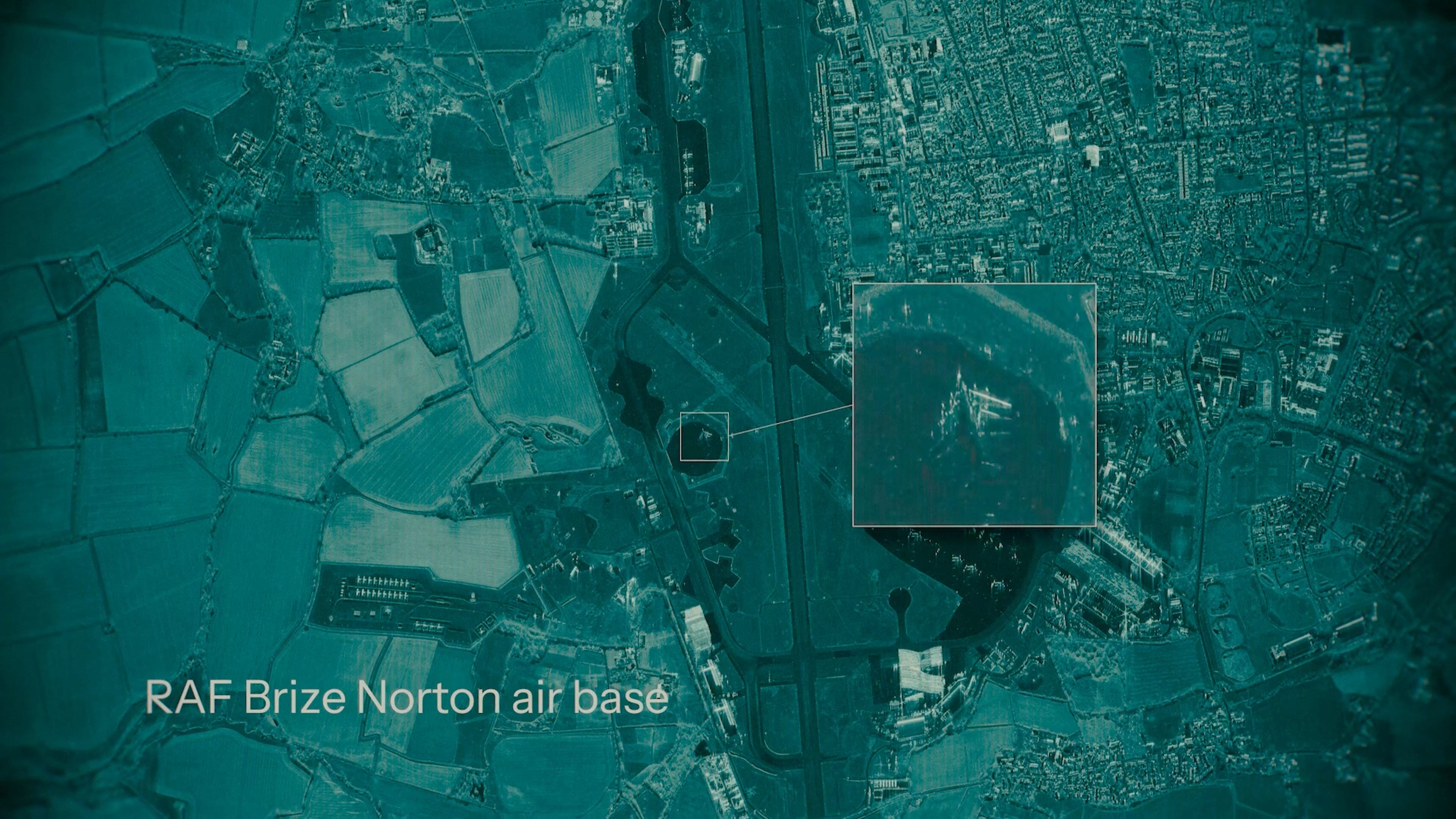
Imagine it’s 2 AM in Eastern Europe. Overcast, no moon in the sky. A column of vehicles is moving across an unlit road. There’s a thick cloud layer sitting at 3,000 feet. To anyone watching from space with a normal camera, that road is empty.
But one satellite in orbit, 400 miles up, fires a radar pulse straight through the cloud cover, through the darkness, and picks up every vehicle on that road. It measures their speed. Their heading. And when one of them pulls off and parks near a structure, it flags the change -- down to the centimeter.
No human looked at this data. An AI read it in seconds.
This technology exists right now. It’s not classified. And some of it is even free.
I’ve spent the last few months using open-source intelligence -- including satellite data -- to reconstruct global events like the Iran strikes and the Hormuz crisis. And on the defense and intelligence side of all that, synthetic aperture radar -- SAR -- is foundational to how a lot of it actually works.
Here’s what it is, why it’s about to be everywhere, and why that should make you both excited and a little uneasy.
How It Actually Works
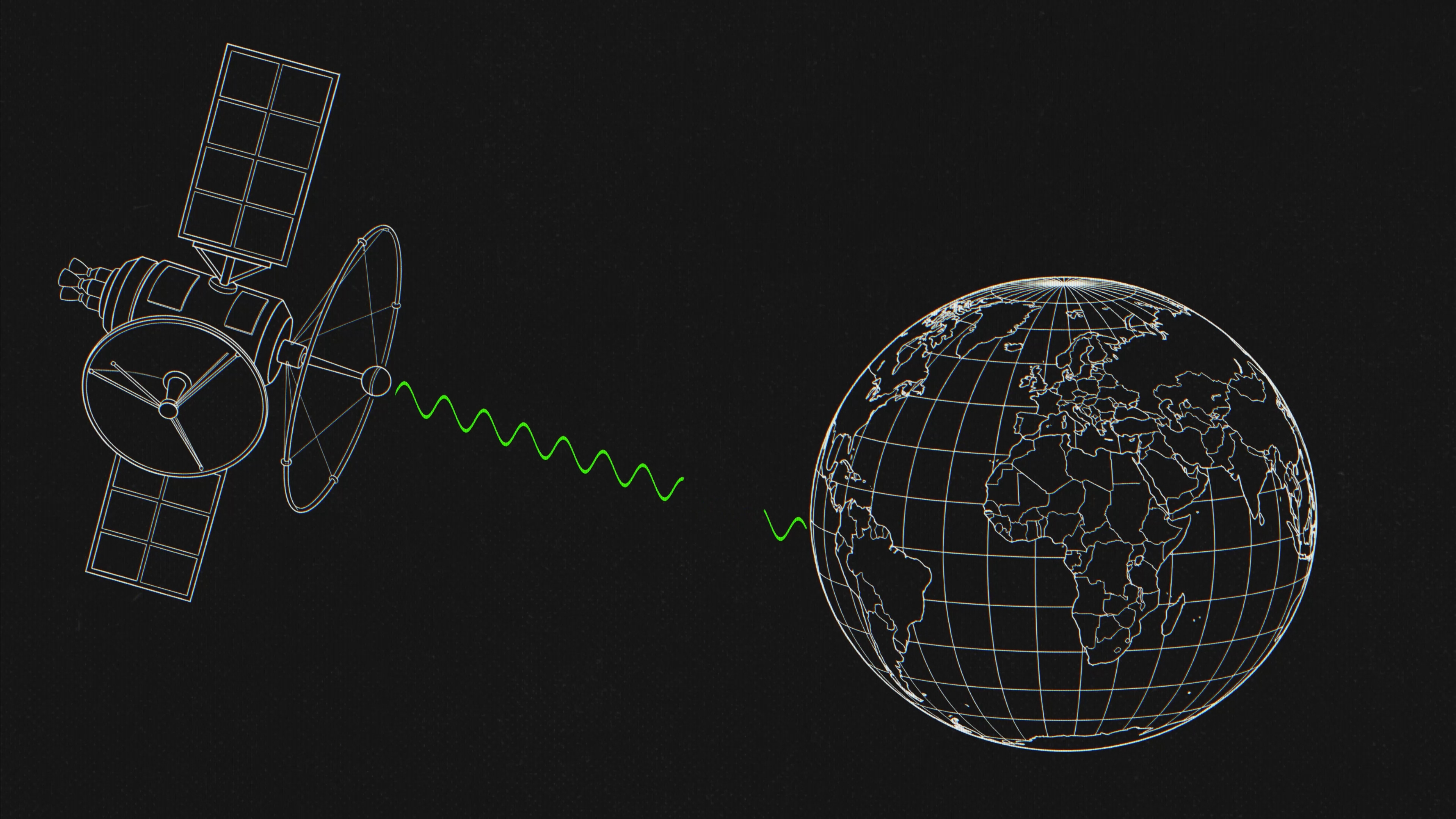
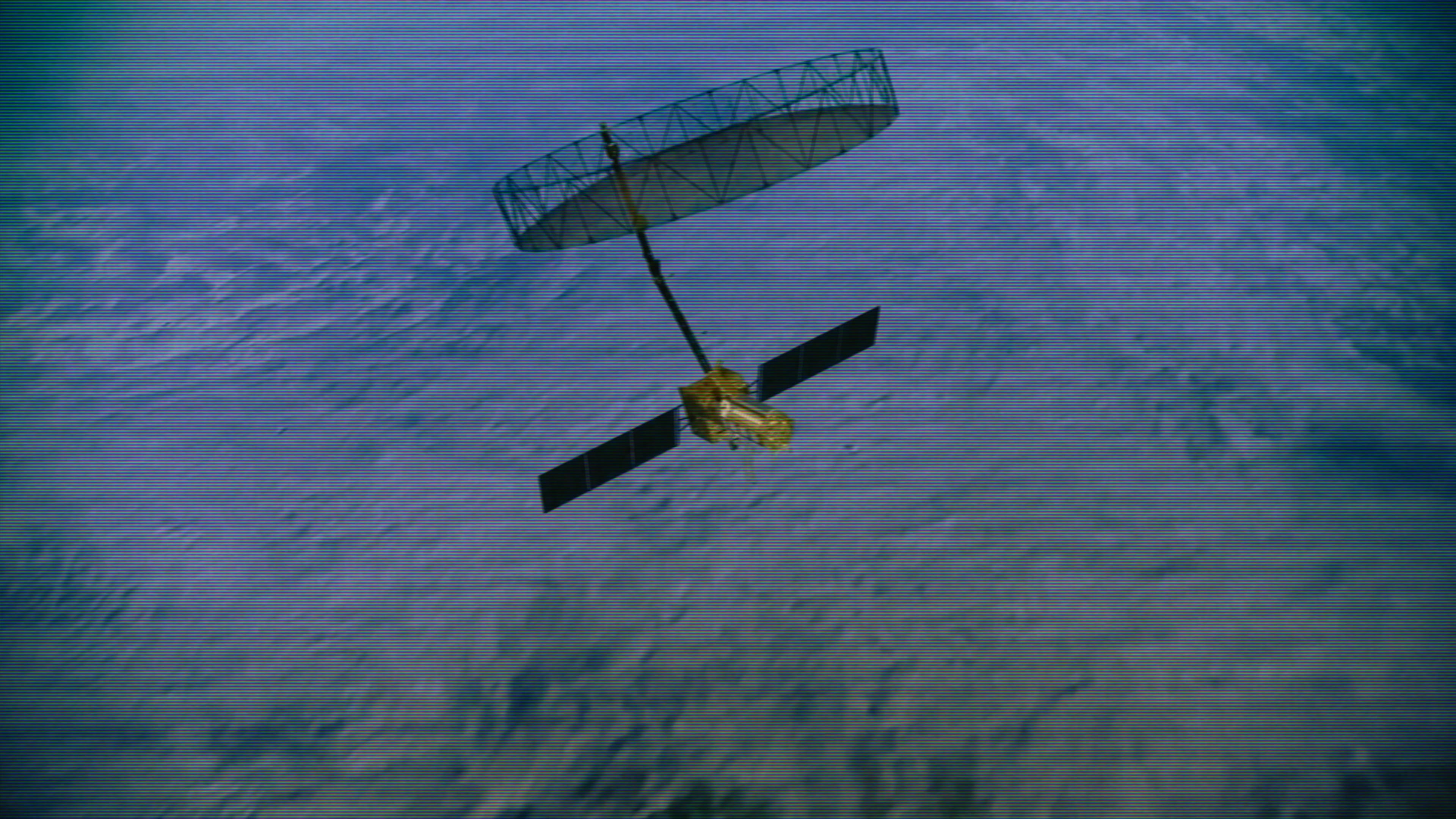
Synthetic aperture radar. Satellites fire microwave radar pulses toward the ground and measure what comes back. Pretty standard stuff if you think about it.
But here’s the clever bit. A single radar antenna in space gives you a blurry image. These satellites aren’t static though -- they’re moving, and as they do, they’re collecting thousands of radar returns from slightly different positions. Stitch them all together and you’re basically faking a really long antenna out of pure motion. That’s where the name comes from. Synthetic aperture.
The result is a 25-centimeter resolution reproduction from space. And what makes SAR different from every electro-optical satellite up there is that it does not care about clouds. Doesn’t care about darkness, smoke, or rain. Optical satellites go completely blind in bad conditions. SAR just punches right through.
Then there’s a technique called InSAR -- Interferometric SAR. You take a radar image of the same spot today, and again several days later, and you start stacking them. What this lets you do is compare tiny phase differences and produce a deformation map -- a record of how much something moved at sub-millimeter precision. Stuff no human eye, not even most physical sensors sitting on the structure, could catch.
The really high-res stuff is either pay-to-play or available only on the defense side. But there’s a satellite constellation in orbit doing this for free, and it’s called Sentinel-1. It covers the planet on a 12-day cycle and anyone can pull it. Pretty fricking powerful for a free tool.
Watch the full breakdown here:
The Pyramid
If you’ve seen SAR mentioned anywhere before, it’s probably because of this.
Researchers used a technique called SAR Doppler Tomography -- or Tomo SAR -- from this Italian satellite called COSMO-SkyMed, and they used it to map the interior of the Great Pyramid of Giza from space.
I want to be precise about how this thing actually works, because it’s wilder than just “radar sees through stone.” The radar isn’t passing through limestone like an X-ray. COSMO-SkyMed uses X-band -- a 3-centimeter wavelength that bounces off surfaces. What the researchers actually did was analyze the micro-vibrations of the pyramid itself. Just the Earth humming -- seismic background noise that propagates through the structure differently depending on what’s inside. Voids, chambers, density changes. The satellite reads those tiny Doppler shifts in the reflected signal and reconstructs a coarse 3D map of what’s in there.
This is peer-reviewed and published in remote sensing literature.
To put it simply: they mapped the inside of a 4,500-year-old pyramid from space by listening to it vibrate. That is fricking cool.
Sinking Cities And Bridges That Aren’t Supposed To Move
It doesn’t stop at ancient monuments. The same InSAR technique, applied to the world’s biggest river delta cities like Jakarta, Bangkok, and Shanghai, shows us something pretty alarming. These cities are sinking faster than the sea levels are rising.
This tech can detect sinkhole formation weeks before the ground opens. And after earthquakes or floods, it tells first responders which structures have shifted before anyone sets foot near them. The crazy part is this data’s been sitting there for years. It’s just a matter of reading it.
Now let’s talk about things that really aren’t supposed to move too damn much. Bridges.
A team of researchers analyzed 744 long-span bridges globally using stacked Sentinel-1 data and published it in Nature Communications back in October 2025. The findings kind of blew my mind. North American bridges are in worse shape than African bridges. Worse than anywhere else on the planet. This is literally aging infrastructure showing up on a satellite map.
There are 46,000 structurally deficient bridges out there in America. Most of them get a physical inspection every two years -- someone drives out, looks at it, writes a report. These satellites can watch all of them every 12 days. Automatically. And when you add satellite monitoring to the mix, it actually cuts a bunch of the high-risk classifications by a third. Bridges we thought were about to fall turn out to be fine. The ones genuinely at risk, we catch them way earlier.
And again -- since this is Sentinel-1, the data is free.
The Village That Was Moved To The Wrong Place
This one I can’t stop thinking about.
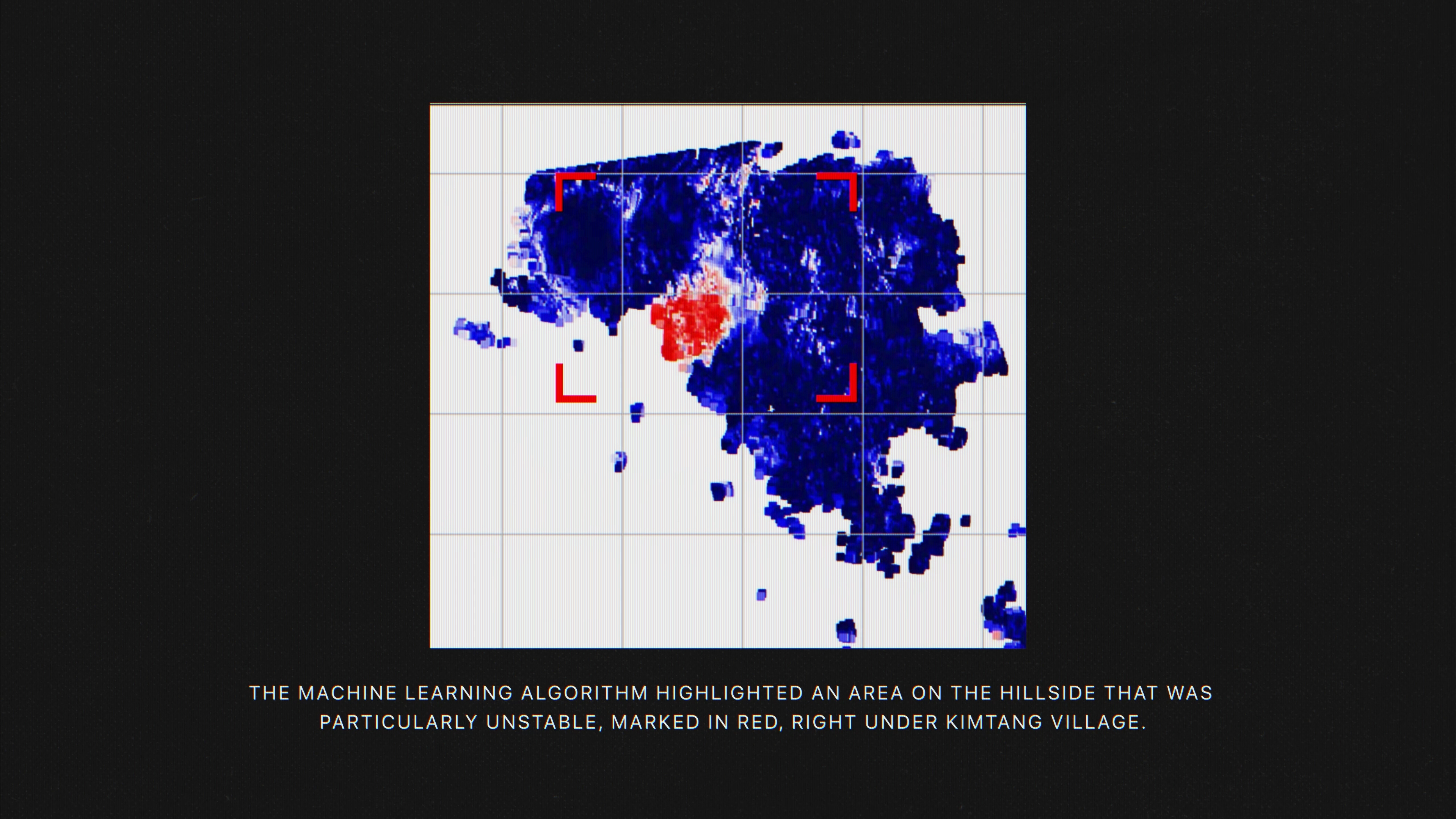
A team at the University of Melbourne built a physics-guided machine learning system that takes Sentinel-1 data and runs it through an AI trained on how ground actually fails -- soil particles separating, microfractures propagating. It generates a risk map that highlights unstable slopes before anything visible happens on the surface.
And they pointed it at a village called Kimtang, in central Nepal.
Here’s where this gets really heavy. The people living in this village had been relocated there in 2019 after a landslide destroyed their previous village. The government moved them there thinking it was a safe location.
And this AI model flags a massive high-risk zone -- completely in red -- directly beneath that village. They were quite literally moved to the most dangerous spot in the region, and nobody had any idea until an AI read the radar data from space and caught it.
The British Geological Survey ran the same approach across all of Great Britain. 300,000 slopes analyzed. 3,000 actively moving. Affecting 14,000 km of road and 360 km of railway. Then after the 2025 Sumatra landslides, the same group mapped over 4,000 landslide sites in a single pass. What used to take months runs in hours now.
That’s the AI unlock. We’re not just collecting this data. We’re reading it, at a scale no human team ever could.
The Commercial Arms Race
This is where it stops being a science story and becomes a geopolitical one.
You’ve got ICEYE -- a Finnish company that operates the world’s largest commercial SAR constellation. They launched five new satellites in November 2025. Then six more on March 30th, just a few days ago, on a SpaceX Falcon 9 out of Vandenberg. 25-centimeter immaculate resolution. Their customers include the Polish Armed Forces, the Portuguese Air Force, BAE Systems, and even the insurance giant AXA.
ICEYE is not alone. You’ve got Capella Space, Umbra, and Synspective too. A whole commercial SAR industry that basically didn’t exist a decade ago. And this year, NASA selected ICEYE as one of seven commercial SAR providers for Earth science research.
The reason nations and defense contractors alike are buying into commercial SAR at this pace? Because of what comes next.
What The Military Already Knows
Everything we’ve talked about so far -- pyramids, sinking cities, bridges, landslides -- that’s the civilian side. Same technology, very different purpose on the military side.
One of these capabilities is called GMTI -- Ground Moving Target Indication. SAR filters out everything that isn’t moving. Ground, buildings, trees -- all gone. Anything left is in motion. Vehicles. Ships. Convoys. In the dark, through the clouds. And if you’ve got longer wavelengths, through jungle canopy. The military calls that FOPEN -- foliage penetration radar. You can detect vehicles and even people hidden under very dense tree cover from an aircraft. That’s real tech, and it exists right now.
The US used to do a version of this from an aging aircraft called the E-8 JSTARS. Circle overhead, track ground movements. That plane is retired now. But what replaces it isn’t another plane -- it’s a constellation of satellites that do the same thing from orbit. Continuously.
The Space Force and the NRO -- the National Reconnaissance Office -- are building exactly that capability. GMTI satellites launching in 2028. At full operational capacity, we’re talking about tracking every moving ground target globally in near real-time. They’re targeting the early 2030s.
And then AI closes the loop. Booz Allen built a system for the Air Force that takes all this SAR data and automatically classifies ground vehicles -- five classes, greater than 90% accuracy. Trained in five months using synthetic SAR images because there wasn’t enough real data. NATO is working on the same thing at alliance scale.
Chain it all together -- persistent SAR constellations, GMTI filtering, AI classification -- and you get a system that watches every road in every country, flags anything that moves, identifies what it is, and tells a human within minutes.
If you remember that convoy at the start of this post -- that’s not a hypothetical. That’s an acquisition schedule.
What’s Next On The Horizon
Last year, NASA and the Indian Space Research Organisation launched NISAR. For global monitoring -- not spying. For that purpose, it is the most advanced SAR satellite ever built, at an estimated cost of $1.5 billion.
On the commercial side, the push is toward what Capella calls “Earth intelligence infrastructure.” Not raw data -- processed insights delivered to operational workflows in near real-time. Monitoring as a service. You don’t parse the data yourself. You subscribe to be notified for the kinds of change you care about.
The honest final unlock with all of this stuff is just time. Sentinel-1 revisits the same spot every 12 days. As more constellations come online, those revisit rates drop to hours. Then minutes. And at some point you’re no longer looking at snapshots of the Earth. You are watching it live. All of it. All the time.
So What Do We Actually Do With This
SAR is some insanely cool and powerful tech. One technology -- radar from space -- can tell you which bridge is about to fall, which hillside is about to collapse, and what’s hidden inside a 4,500-year-old pyramid. AI can now read it faster than any human team ever could. And every month, more satellites go up.
On one hand, we can respond to landslides, monitor critical infrastructure, react to disasters faster than ever before. There’s a village in Nepal that should have been moved before the ground gave way -- this technology was the thing that finally noticed.
On the other hand, that exact same technology can track every vehicle on a grid. In pitch black. Through heavy cloud cover. With an AI automatically cataloging every single target. We are weeks, not years, from a world where if it’s outside, it’s seen.
SAR is just another layer of sensors adding to how we monitor the entire planet at once. Flights, shipping, GPS interference, satellite imagery, and now radar that sees through clouds, darkness, and stone -- all stacking on top of each other. The more layers we add, the harder it gets to hide anything on the surface of the Earth. The capability is already here. More of it is coming online. So you should know about it. But what we do with it -- that’s the part that’s still being written.
If you’re curious about how to use radio frequency as a sensing modality -- WiFi, 5G, the kind of stuff that lets you see through walls without satellites at all -- I made a video about that one too. Check it out.
If this gave you something to think about, share it with someone who should see it. Reality is getting more legible than most people realize.
-Bilawal
SAR is cool so too is LiDar as well :) https://www.nationalgeographic.com/history/article/maya-laser-lidar-guatemala-pacunam
We built this thing https://ottawacitizen.com/news/national/defence-watch/canadian-surveillance-satellite-system-now-operational teams of people we were responsible for the data collection portion https://github.com/eodms-sgdot huge amounts of data comes from those satellites daily 1.5TB https://aws.amazon.com/blogs/publicsector/how-natural-resources-canada-migrated-petabytes-geospatial-data-cloud/ does it really need to be that way? why not space cloud process what you need up there then send it down quickly via one-web or starlink via laser comm links
ref cool launch video https://www.youtube.com/watch?v=gszJYTNtzLo . https://www.eoportal.org/satellite-missions/rcm . https://spaceq.ca/the-defence-and-security-applications-of-the-radarsat-constellation-mission/https://www.asc-csa.gc.ca/eng/news/articles/2025/2025-11-03-30-years-radarsat-data-canada-legacy-earth-observation.asp an oldie but a goodie https://spaceq.ca/radarsat-1_mission_officially_declared_non-operational/
https://www.tomshardware.com/tech-industry/artificial-intelligence/self-assembling-data-centers-in-space-are-becoming-reality-as-rendezvous-robotics-partners-with-starcloud-elon-musk-chimes-in-that-spacex-will-be-doing-this
https://nationalpost.com/news/canada/canadian-startup-new-satellites-defence-ai-observation Gone are the days of large antenna stations? perhaps as small sats take off eh! https://smallsat.org/ . https://www.cubesatshop.com/ but what about the space junk? https://platform.leolabs.space/visualization . https://www.esa.int/Space_Safety/Space_Debris don't leave poop in the sandbox, clean it up.
and if you need it encrypted this is coming too https://uwaterloo.ca/institute-for-quantum-computing/research/qeyssat for those big defense projects
(ref https://www.whitehouse.gov/articles/2025/09/president-trump-tech-leaders-unite-american-ai-dominance/ . https://www.intereconomics.eu/contents/year/2025/number/2/article/big-tech-and-the-us-digital-military-industrial-complex.html )
All great stuff from the great white north :) don't forget about us up here we have a huge landmass but most of it so inhabitable yuk winter :)
I think gdal has a SAR processor? https://wiki.osgeo.org/wiki/GDAL_SoC_Ideas/SAR_Processor we were trying to incorporate some GPUs into our stuff but I'm not too sure how far that went so much of the SAR processing is done by MDA for now. (ref https://gdal.org/en/stable/ . https://qgis.org/ )
If you are looking for a SAR processing body this guy knows his stuff https://www.linkedin.com/in/valentin-poncos-7589009/ we built this as well (dual IR missile tracking system for the naval ships ) https://www.hpcwire.com/2001/01/05/drs-selects-race-systems-for-missile-system/
SAR is cool stuff though, we need more of it and there is more competition coming with the likes of https://www.iceye.com/blog/dr-alan-thompson-vice-president-spacecraft-engineering-shares-his-experience-and-thoughts-on-sar-satellite-missions . https://www.iceye.com/newsroom/press-releases/advancing-sovereign-intelligence-from-space-iceye-launches-six-new-satellites-aboard-transporter-16 we lost a great scientists there. And, the Government of canada just cut a bunch as well https://www.reddit.com/r/CanadaPublicServants/comments/1r26l27/nrccnrc_laying_off_hundreds_of_talented_scientists/ shameful what is happening up north with the current admin. More concerned about housing than science or real engineering.
When I worked at NRCan https://natural-resources.canada.ca/science-data/science-research/research-centres/canada-centre-remote-sensing we had some great scientists last cuts seen most of them go as the politicians don't like science. The department now hands out awards to admin not science anymore. Shameful really shameful.
We need more great science and engineering work. Useful and useable stuff for the world to see and use in a good way not an evil way. Never never evil ways.
map it spatially and temporarily as everything can be mapped in space and time due to some triggering event.
When I opened Substack today for a morning-with-coffee read, little did I suspect I would close it after reading what amounts to a non-fiction horror story. :)
But seriously-- WOW, that spyware is certainly thought-provoking. It will be interesting to see what happens during the, let's say, next 12-months (hurries to create reminder for 16-Apr-2027).
Thanks again Bilawal, another great read.