
The Intelligence Monopoly Is Over. Creating a God's Eye View of the Iran Strikes.
How I Reconstructed Operation Epic Fury From My Couch Using Public Data And An Army of AI Agents.

A week ago, I built WorldView — basically a geospatial command center that fuses open-source intelligence feeds onto a 3D globe. It was a weekend project. The internet went kind of crazy over it. One person joked I’d “vibe-coded Palantir.” The actual co-founder of Palantir felt compelled to respond on a live show.
Then Saturday morning, the Iran strikes happened.
I’m sitting on my couch watching the news and I realize — holy crap, I have the exact infrastructure to monitor this. So I did what any reasonable person would do: I sent a WhatsApp message to my AI agent and told it to start recording everything.
By evening, I had banked every open-source signal I could find before the caches cleared. What came out the other side is a full 4D reconstruction of Operation Epic Fury — from the military and commercial satellites overhead to the cascading airspace shutdowns across the Gulf. Replayable, scrubbable, minute by minute on a 3D globe.
And I did it over the weekend. By myself.

The Layers
Here’s what you need to understand about open-source intelligence: each data source by itself is kind of meaningless. ADS-B flight transponder data? Cool, you know where some planes are. Satellite orbital elements published by NORAD? Great, you can track objects in space. Maritime AIS beacons? Ships are moving around.
None of this is hidden. None of this is classified. It’s all just... out there.
But when you start layering these pieces together on the same timeline, on the same 3D globe, something weird happens. The picture that emerges starts feeling classified-grade. The whole becomes dramatically greater than the sum of its parts.
For the Iran reconstruction, I fused six primary layers:
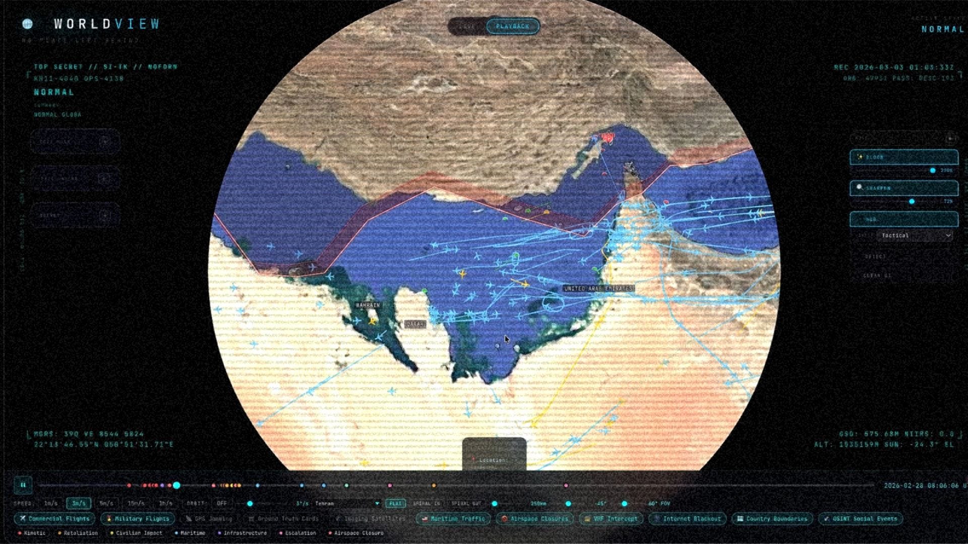
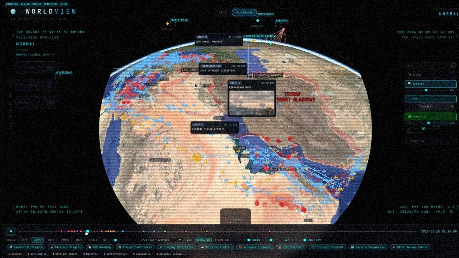
Commercial flights. 3,400+ aircraft tracked via ADS-B. You can watch the airspace clear out in real time as the strikes approach — flights literally routing around Iran, going “nope, I’m getting the hell out of dodge.” A few brave Turkish Airlines flights went full Leroy Jenkins straight through. Imagine being a passenger on that flight.
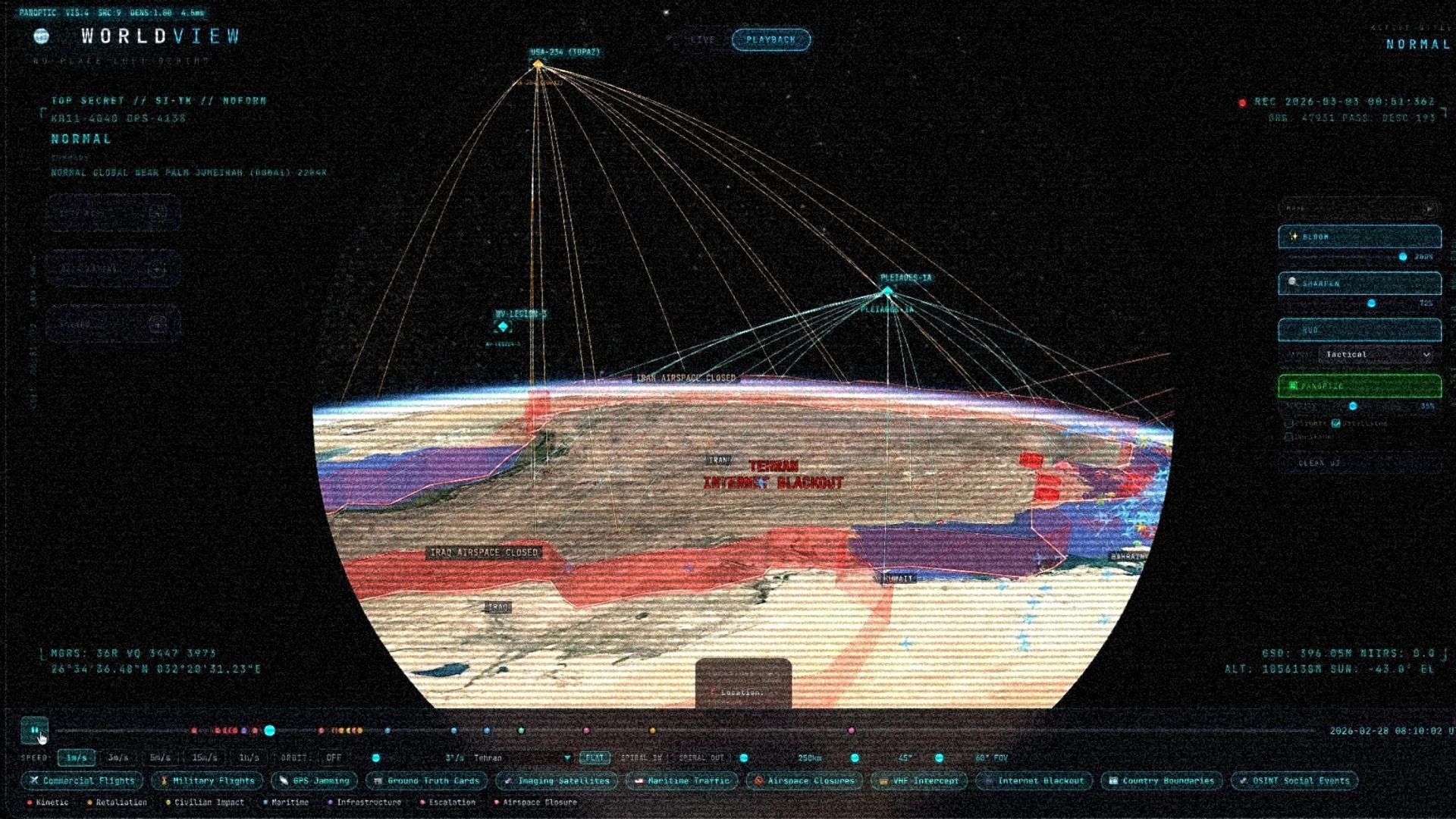
Satellite constellations. This one blew my mind. Using publicly available orbital data, I mapped every commercial and military satellite that was in orbit over Iran before, during, and after the strikes. American KH-11 Keyhole spy satellites. Russian BARS-M reconnaissance birds. Chinese Gaofen dual-use microwave sensing satellites. Capella synthetic aperture radar — the same tech that saw through the structures beneath the pyramids (and can more usefully see through clouds and at night). Because of massive constellation density, their natural orbital tracks constantly intersected over the exact same patch of Earth.
The moment that got me was scrubbing through the timeline and realizing: wait, is that a Russian reconnaissance satellite passing directly over the strike zone right before zero hour? And then right after, the next Chinese and American satellites in the constellation lined up to image the aftermath. Everyone wanted to see what just happened. While we can’t get access to the tasking priorities to really know the exact AOIs of all these orbital passes — damn does this feel close.
GPS jamming. This is the sneaky one. Every commercial aircraft broadcasts its GPS confidence level. When you aggregate enough of those signals, you can map where active GPS interference is happening — without any classified sensors at all. You’re basically mining the global fleet of commercial aircraft as a distributed sensor network for electronic warfare. And man, did the jamming light up before the strikes.
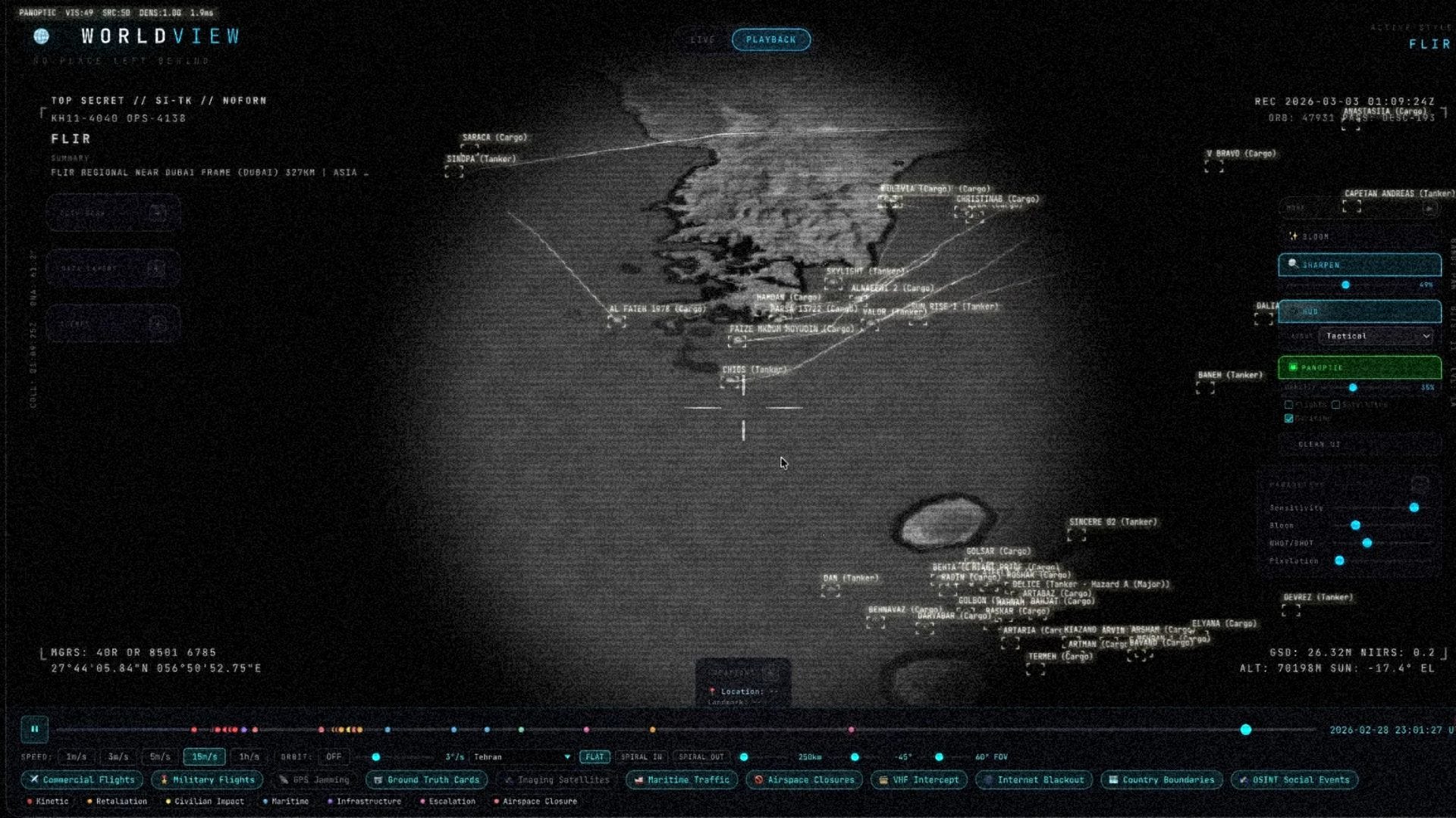
Maritime traffic. The Strait of Hormuz is one of the most critical shipping chokepoints on the planet. When the Islamic Revolutionary Guard effectively shut it down, you could watch the panic in real time — tankers scattering, one vessel getting hit, commercial shipping fleeing the bottleneck. Just think about mapping the commercial implications of these movements — South Korea has literally entered a state of emergency, because this closure threatens 70% of their crude oil imports and 20% of it’s LNG.
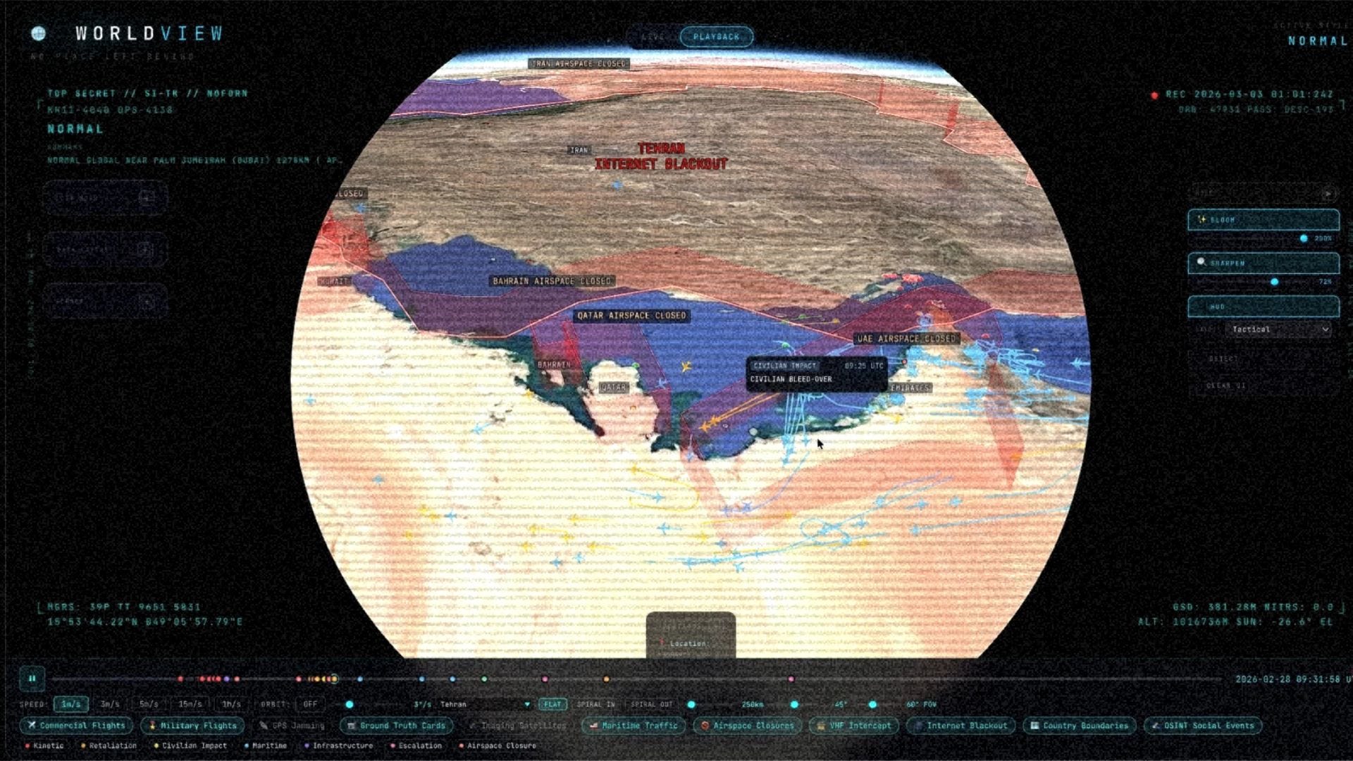
No-fly zones. The cascading airspace shutdowns told a story on their own. Iran goes dark. Then Iraq. Then Kuwait. Then the retaliatory strikes hit US bases in Bahrain and Qatar — al-Udeid, the Fifth Fleet — and suddenly half the Gulf is a no-fly zone. One of the busiest commercial air corridors in the world, completely emptied.
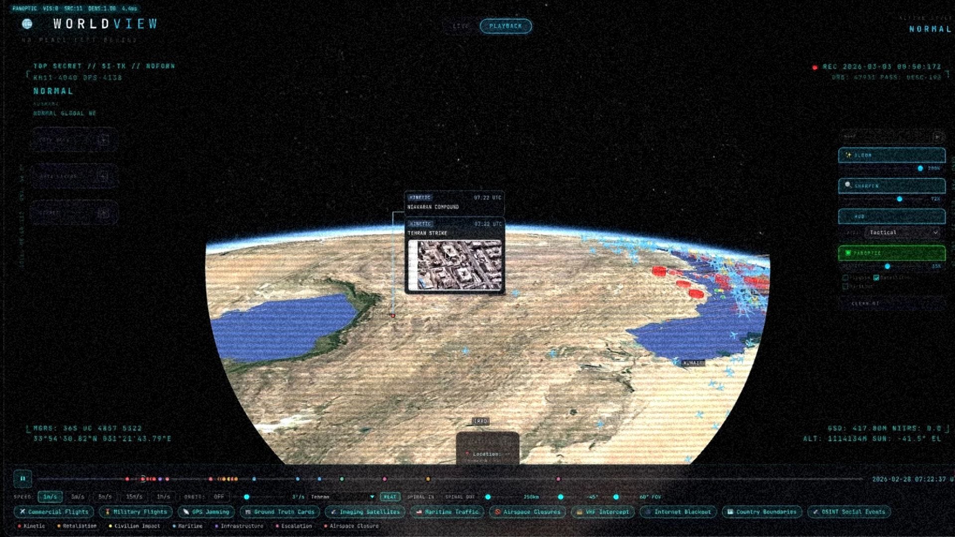
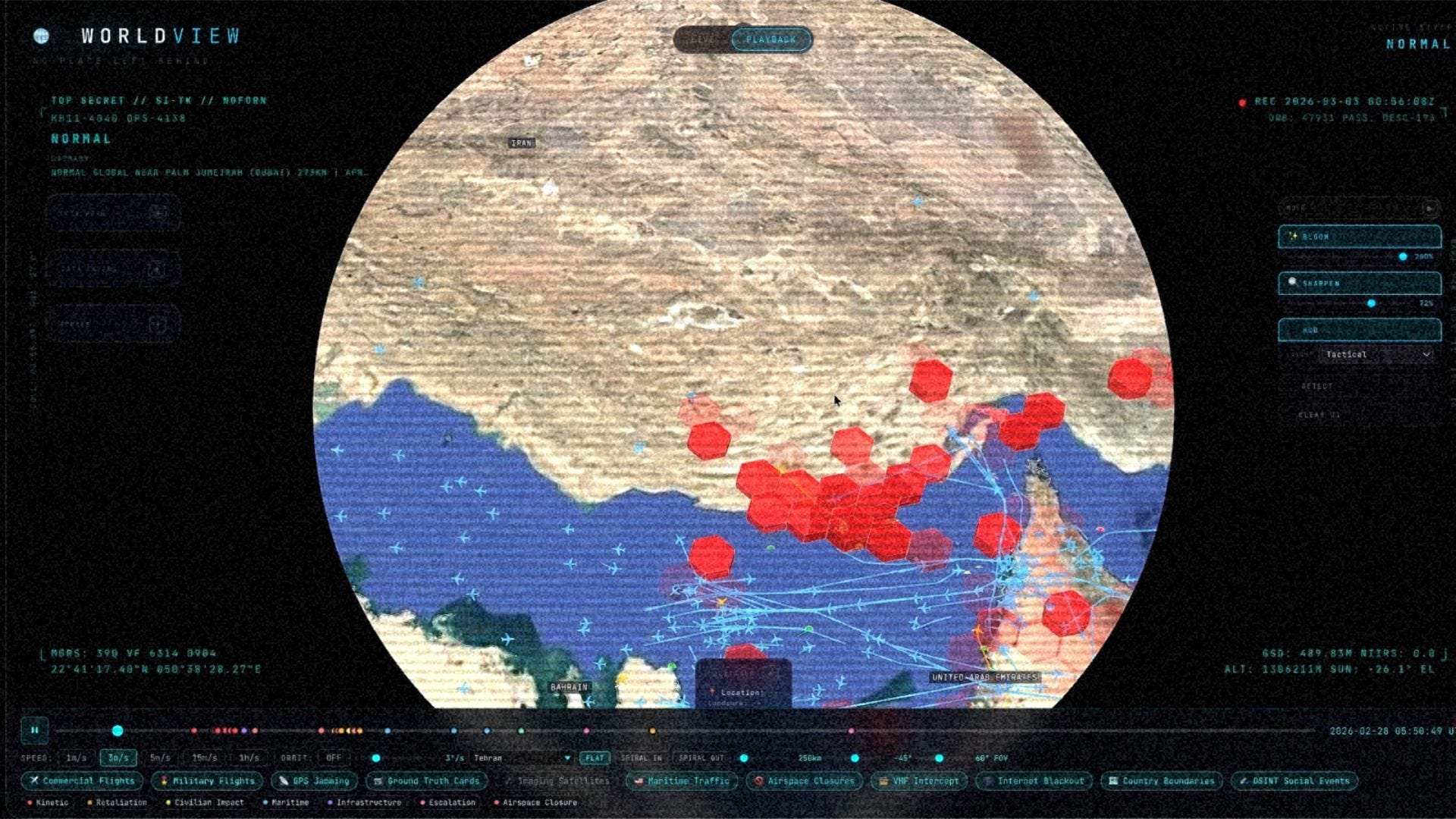
Strike coordinates. Geolocated from open reporting and correlated against everything else. This is the area where there’s much more work to do. I was able to take public reporting and corroborate it with official sources — but so many of those conflict depending on which journalistic outlet you look at. I decided that would only graduate the highest confidence events to the map.
Layer all of this together and you can watch Operation Epic Fury unfold minute by minute. Not from a CNN desk with a red dot on a country-shaped outline. On a 3D globe with actual flight paths, actual satellite passes, actual GPS interference zones, actual ship movements. All from public data.
The Absence Is the Signal
One of the things that’s hardest to explain about OSINT is that what disappears tells you as much as what appears.
Military aircraft can and do turn off their transponders. So you don’t see them directly. But when you suddenly have a hole in the map — an area where there should be commercial traffic and there’s nothing — that itself is intelligence. When 3,400 flights simultaneously clear an airspace, you don’t need anyone with a security clearance to tell you what’s coming.
The GPS jamming data works the same way. You’re not directly measuring the jamming — you’re inferring it from degradation. Every plane that reports a drop in navigation confidence is an unwitting sensor. Aggregate enough of them and you’ve mapped the electronic warfare environment from publicly available data.
This is why the democratization of OSINT is so significant. It’s not that we suddenly have access to spy satellites. We don’t. The US government has sensor systems that can identify a vehicle from orbit. I have NORAD’s public catalog and some API calls.
But here’s the thing — the AI available to the general public is on a pretty level playing field with what the intelligence community has for analysis. The government has way better sensors. But the analytical tools? Those have been commoditized. That’s the shift.

What Used to Take Quarters
I spent six years at Google, four of them on Maps. I worked on the ARCore Geospatial API, Immersive View, 3D mapping at global scale — fusing satellite, aerial and ground level imagery together for public and private sector applications. I’ve worked with incredibly talented engineers on projects like this. We would spend quarters — literal three-month cycles with full teams — to build what I just built over the weekend.
The AI agent swarm changed everything. During the strikes, I was on my couch. I sent a message to my agent. It started snapshotting every data feed before the caches cleared. When the dust settled, I had all the raw material. Then came the fun part: fusing it all together, aligning the timelines, and building the visualization.
That responsiveness would not have been possible before AI. Certainly not for one person. A couple years ago, you’d need a team just to do the data engineering — normalizing formats, aligning coordinate systems, cleaning timestamps. Now you jump straight to the human analysis part, which is where the interesting work actually is.
There’s a quote from Major Claire Randolph of the Air Force Central Command that I keep coming back to: “If American analysts were doing some of these things, we would classify that as secret or perhaps even top secret. But this stuff is just out there on the open internet.”
She’s right. And it’s only going to get more true. Fuse enough public data together and you get a picture that is greater than the sum of its parts.

The Trillion-Dollar Question
Here’s the part that keeps me up at night.
The US government officially recognized the value of OSINT in 2024. Small teams of analysts punching way above their weight compared to classified systems. That same year, Anthropic’s Claude started operating in classified settings for the Department of Defense. The analytical capability gap between a motivated individual with public tools and a nation-state intelligence apparatus is narrowing fast.
Which raises an uncomfortable question: how much of this is transparency, and how much of it is a genuine security risk?
Journalists track fleet movements by watching TikToks from people who live near naval bases. Satellite imagery that used to be the exclusive domain of three-letter agencies is now purchasable by hedge funds trying to count cars in parking lots. The same commercial satellite capacity that the military buys for routine coverage is available to anyone with a credit card.
I don’t have a clean answer. I don’t think anyone does. The data is just... out there. What’s the alternative — close down the internet?
But what I do know is this: the intelligence monopoly is over. The question isn’t whether individuals and small groups can do things that used to require a security clearance. They already can. The question is what we do with that capability.
I’m building tools that make the world more legible. That fuse public data into spatial understanding. That give anyone the ability to see what’s actually happening — not through the lens of a cable news desk with a red dot on a map, but through actual data, on a globe, scrubbed minute by minute.
Stay tuned for more.
The full video breakdown of the Iran reconstruction is on YouTube:
If you want to follow the build, I’m @bilawalsidhu on X: https://x.com/bilawalsidhu
Bilawal, signing off. ✌️
BIlawal, what you have done with this series is not just create a beast of a machine, but shown the rest of the world what is able to be done in real time now, if we are allowed to dream and create with NO GATEKEEPERS! The future is here whether they like it or not!
Our boy Bilawal Sidhu shows how exactly he achieved this over the weekend.
For truth is not only stranger than fiction but also effectively free, if you know where to look for it.
https://youtu.be/0p8o7AeHDzg?si=3zKC9sCdUatWfNRy